

Drone Photography
Showcase your property and its surroundings from breathtaking angles. Drone photography can capture a large piece of land and its features or view a neighborhood and surrounding points of interests.
Our drone pilots are FAA certified and ready to capture an aerial view sure to amaze potential buyers and ensure that you seal the ultimate deal. Get ready to impress with our drone photos & videos.
Drone Photos


Just $79
Drone Photography includes:
-
12-15 Drone Photos
-
1 - Street View Photo
-
1 - Plot Line Outline Photo
-
Delivered Next Day
*Lot outline lines are estimates
Drone Video


Just $99
Drone Videos Include:
-
<1min Video
-
1 - Animated plot line clip
-
1080p quality
-
Downloadable .mp4/.mov format
-
Link hosting/embed
-
Delivered in 2 business days
*Points of interest and/or Property info animations are available for a fee
**Lot outline lines are estimates
Premium Photography
0 - 2000 sqft - $135
2001 - 3500 sqft - $155
3501 - 4500 sqft - $175
4501 - 6000 sqft - $195
$175 Drone Bundle
Order photos and video for a discounted price
According to the MLS, homes displayed with aerial shots are 68% more likely to sell
National Board of Realtors, NAR
Drone Product Features
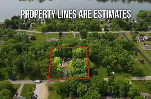
Property Outlines
Estimated property outlines define the area. Whether drawing focus to the correct property in a line of houses in a subdivision, or a vast lot of land without geographical references, your properties will stand out with drone photography.
Aerial drone photography is a powerful and compelling tool in the land marketer’s arsenal.
Land.com Network
Vacant Lot/Land

Listing agents who use drones for real estate could see an increase in listings as high as 73%
RISMedia
Commercial Property Drone

JPG Media Commercial Drone Photography captures areas of the entire area, special features and points of interest, as well as proximity to important selling features such as access routes, etc.

JPG Media Commercial Drone Photography captures areas of the entire area, special features and points of interest, as well as proximity to important selling features such as access routes, etc.

JPG Media Commercial Drone Photography captures areas of the entire area, special features and points of interest, as well as proximity to important selling features such as access routes, etc.